遥かなる わがヨークシャー (Faraway My Yorkshire)
ノース・ヨーク・ムーアズ (The North York Moors)
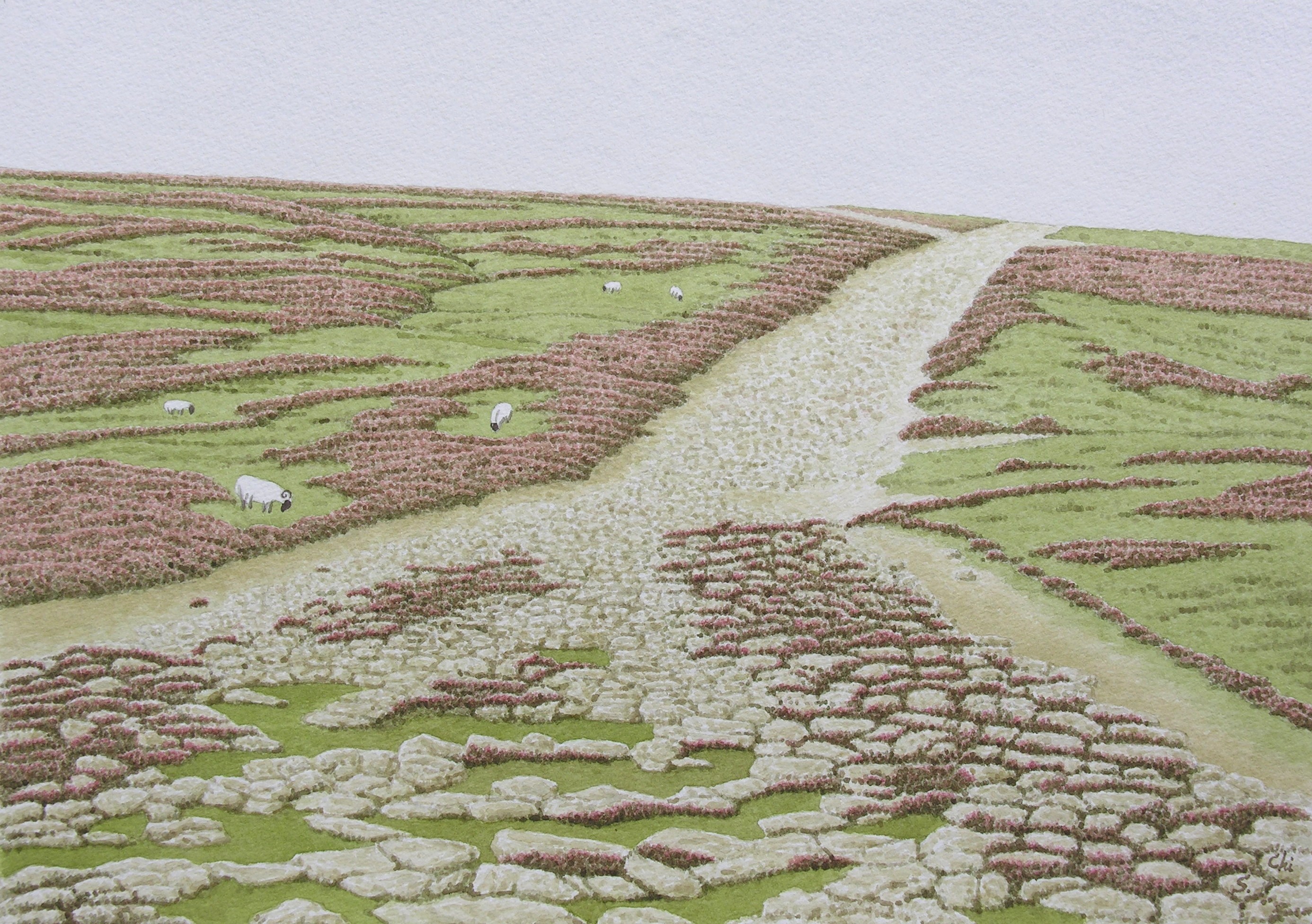
79 ウィールデイル・ムーアのローマ街道 (Roman Road at Wheeldale Moor)
ノース・ヨーク・ムーアズのなかのウィールデイル・ムーアに、かつてブリテン島がローマ帝国の一部であった時代の名残がある。ローマ街道である。
ここのローマ街道は、イギリスでももっともよくその様子を伝えているところだというので、出かけていった。
ウィールデイル・ムーアは、見渡すかぎり、ヒースでおおわれた荒野であった。そのなかに、ヒースの絨毯を切り裂くように、石がゴロゴロと一直線につづいているところがあった。それがローマ街道だった。石の大きさは数十センチで、それがただゴロゴロとつづいているので、道というよりは、川原のようであった。
ここへ来るまで思い描いていたローマ街道は、写真で見たことのあるイタリアのアッピア街道のように、敷石できれいに舗装されたものだった。しかしウィールデイル・ムーアのローマ街道は、それとは比べ物にならないほど荒れていた。
石がゴロゴロとしているところを歩いていると、ところどころに、平らな石がつづいているところがあった。わたしには、それが敷石舗装の名残のように思えた。石の角は、千数百年間以上の風雪によってすり減り、すっかり丸くなっていた。
ローマ街道の両側のヒースは、道の中に入り込まないようにと、数メートルの幅で剥ぎとられていた。それでも、道の中にヒースが侵入しているところがあった。そして石と石のあいだのすきまで、淡い桃色の小さな花をたくさん咲かせていた。それは、ローマ帝国のかつての栄光を伝えるために、荒野が織りあげたレースの断片ようであった。その切れぎれのレースは、荒野を吹き抜ける冷たい風に、静かに揺れていた。
説明板によると、このローマ街道は、ヨークの北東およそ27kmのところのマルトンにあったローマ軍の駐屯地と、北海に面したウィットビーの沿岸監視所をつなぐものだった。
3世紀のなかごろか、属州ブリタニアの北海沿岸は、たびたびアングロ・サクソン人の海賊に襲撃されるようになった。ローマ軍は、海岸線に沿っていくつも信号所や監視所をつくり、それらをローマ街道でつないでいった。そしてローマ軍は、サクソン人があらわれたとの知らせを受けると、銀鷲の軍団旗アクイラを先頭に、赤いマントをひるがえしながら、撃退すべく出撃していった。
説明板によると、いまゴロゴロと転がっている大きな石は、表面の敷石ではなく、基礎に使われていたもので、かつてはその上に細かい砂利の層があったという。
またほかの解説書によると、ローマ街道はふつう、砂の層の上に大きな石をならべて基礎をつくり、その上に砂利を約45cmの厚さに敷きつめ、さらに最後に、表面を平らな石、もしくは現地で調達できる最適の資材で舗装していたとも言われている。
ローマ軍は、紀元43年のクラウディウス帝によるブリテン島征服後の40年間に、総延長が1万km以上におよぶ道路網を建設したと言われている。
地中海に生まれ育ったローマ人が、このような巨大な道路網をつくりあげたとは、信じがたいことである。
なにしろブリテン島の気候は冷涼で、しかもどんよりと曇っている日が多く、寒い。地中海沿岸地方のような、抜けるような青空は、まず望めない。日が差していると思っていても、すぐに冷たい雨がやってくる。荒野は、いつもぬかるんでいる。寒い季節に荒野で雨や雪にでもあったら、それこそ悲惨である。
それでもローマ軍は、この北国で道路をつくりつづけた。その強固な意志と拡張主義には、ただ驚嘆するばかりである。
英国陸地測量部作成のロード・マップを見ると、イギリスの道路は、幹線道路であっても、よく曲がりくねっている。
ところが、道のある部分だけが、数kmからときには数十kmにわたって、真っすぐにつづいているところがある。それらの部分は、かつてのローマ街道だったところとされている。
イングランド中部の東寄りにあるリンカンから北へハンバー川までの道は、「アーミン街道」と呼ばれてきたローマ街道の一部であるが、約50kmにわたって、定規を使って引いたように、真っすぐである。
厳格なローマ軍にとって、道路はあくまでも真っすぐでなければならなかった。それはまた、ローマ街道の第一義的な性格が軍事道路であり、部隊をできるだけ迅速に移動させるための道路としては、当然のことであった。
しかしのちにこの島の住人となったアングロ・サクソン人にとって、地形や住居に適した場所を無視してただ真っすぐにつくられたローマ街道は、日常生活には使いづらかったにちがいない。そして彼らは、必要に応じて道を曲げるだけの十分な柔軟性と寛容性をそなえていた。その結果として、イギリスの道はよく曲がりくねるようになったのだろう。
アングロ・サクソン人の時代になると、多くのローマ街道は使われることもなく、見捨てられた。そこに用いられていた石は、彼らによって掘りかえされ、建築資材として持ち去られた。そして栄光のローマ街道は、ヒースの生い茂る荒野の中に埋もれていった。
イングランドには、もう1カ所、ローマ街道の様子を伝えているところがある。マンチェスターの北東22,3kmのところのブラックストーン・エッジのローマ街道である。敷石もしっかりとしていて、いまでも使えそうである。馬車の車輪によってできたと思われる轍が、ずうっとつづいている。
しかしここの敷石舗装は、産業革命以前の近世に補修されたもので、ローマ時代のものではないとの議論がある。付近ではローマ時代のコインが発見されているので、この道がかつてのローマ街道であったことは確かなようだ。
いまは失われているが、かつてはローマ街道が通っていたとされるところは、ロード・マップ上に点線で示されている。
ローマ街道は、ブリテン島がローマによって文明化された証であった。たとえ点線で示されようとも、トレヴェリアンが記したように、いまもブリテン島の丘や荒野を越え、森を抜けて真っすぐにどこまでもつづいている。
「ローマ道路は緑の小道としてたどられ、どこから始まって、どこで終わるということもなく、妖精の住む古いイングランドの農村を通りぬけて何マイルにもわたってまっすぐにつづいているのである」 (G.
M. トレヴェリアン著、大野真弓監訳『イギリス史1』、みすず書房)
水彩画に描いたウィールデイル・ムーアのローマ街道は、手前のほうがローマ軍の駐屯地があったマルトン、さらにローマ帝国の第6軍団の本部が置かれていたヨークへとつづいていた。そして絵の奥のほうは、北海沿岸のウィットビーの沿岸監視所へとつづいていた。
As I read that there was a Roman road which was among the finest examples
of Roman road-building in Britain preserved at Wheeldale Moor, I went to
see it.
Wheeldale Moor was covered with heather as far as I could see. And a line of scattered large stones continued there, scraping the carpet of heather. That was the Roman road. But the road was wasted far beyond my imagination. I had expected to see a well paved road like the Appian Way in Italy.
The notice board of the Ministry of Public Building and Works said that
this road "connected the Roaman fort at Malton", 17 miles to
the northeast of York, "with the coast near Whitby and was probably
used in late Roman times as a link with the signal station on that coast".
The board also said that "the large stones visible now formed the
raised central foundation and were originally covered by a fine road surface,
probably of gravel".
The book Iread said that the Roman roads were usually made with a bottom
layer of large stones embedded in sand and covered with rammed gravel to
a thikness of about 18 inches, and the surface was paved with local materials.
Wandering along the rugged road, I found some parts where round flat stones
spread like paving stones. The corners of those stones were worn quiteround
by weathering for more than fifteen hundred years.
Although the heather of both sides of the road was removed to a width of
a few dozens feet, it entered into the road and flowered in the openings
between the stones. And the light pink small flowers were trembling in
the cold wind.
Heather in bloom looked like a piece of lace which the moor wove up to
tell the glorious days of the Roman Empire.
Whenever the the Roman fort received the news of barbarians' raid, the Roman troops, led by the Aquila, a standard of Roman eagle, would march along the Roman roads bravely, flying their red capes.
It is said that the Romans built more than 6000 miles of road network in
Britain during first 40 years after Emperor Claudius had conqured Britain
in AD 43.
It is difficult to believe that the Romans, who were born and grew up in
the Mediterranean, created this vast system of roads. The weather of Britain
is very cool and changeable. Even when it is sunny, there are occasional
sudden showers. It is cold and gloomy when rain falls in the moorlands
in cold seasons. But the Romans built extensive roads in this northern
country. I am just amazed at their strong wills.
Looking at the motoring atlas of the Ordnance Survey, I noticed that the
roads of England , most of them built by the Anglo-Saxons, were quite often
winding. Among them, some roads have sections which run very straight for
several or dozens miles. Such sections are said to have been the Roman
road.
The road, which has been called Ermine Street, runs northwards from Lincoln
to the River Humber. It is straight for 30 miles as if it were drawn using
a ruler. For the strict Romans, the road must be as straight as possible
and it was reasonable for military roads to move the troops fast.
But the Roman roads were not convenient for the Anglo-Saxons, later inhabitants
of this isle, and they were tolerant enough to bend or curve the roads
whenever they need to do so. Consequently, I suppose, the roads of the
British Isle became winding as the case might be. The Roman roads of England
had fallen out of use and been abandoned in the Anglo-Saxons age. They
would take away stones to build their houses.
In England there is another Roman road remaining paving. It is a Roman
road of Blackstone Edge, moorland about 14 miles to the northeast of Manchester.
The paving seems to be usable even now, but there are arguments: the paving
was repaired before the Industrial Revolution, so it is not the Roman origin.
Since Roman coins have been discovered near it, it is thought that a Roman
road had once run here.